
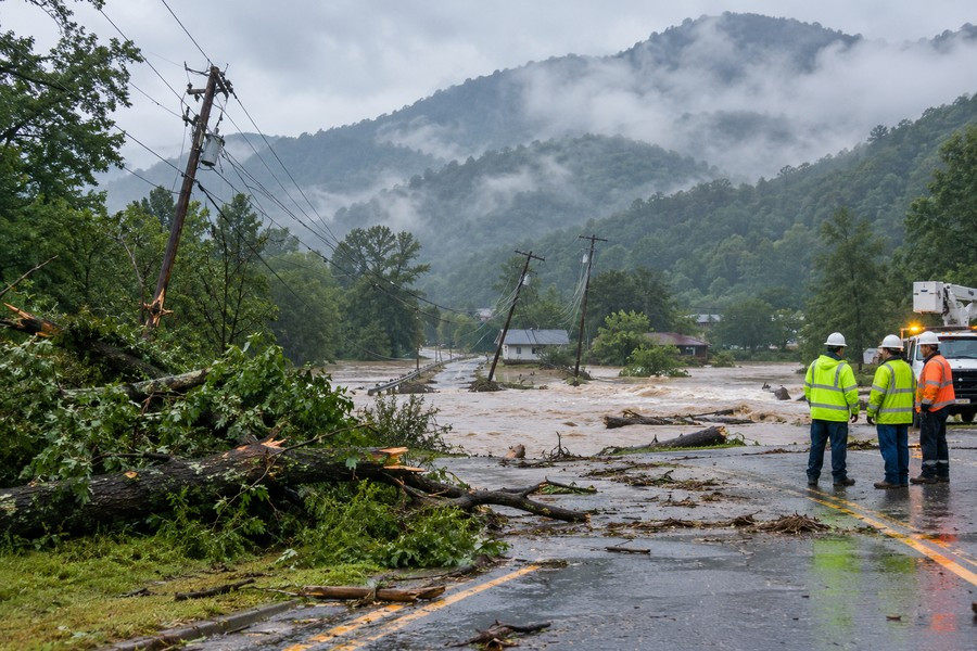
Heavy Rain and Strong Winds Bring Flooding and Power Problems to Western North Carolina
Heavy rain, strong wind, fallen trees and rising waterways are causing dangerous conditions across western North Carolina as the remains of Hurricane Isaias move through the region. Some communities are dealing with power outages, blocked roads, flooded streets and possible landslides.
Power Outages and Road Hazards
Utility crews are checking damaged areas and working to restore electricity. Residents should stay far away from fallen power lines, damaged poles and downed trees. Some repairs may take longer because unsafe roads and strong winds are slowing travel and repair work.
Several areas have reported trees falling onto roads and power lines. Broken poles and damaged transformers have also been found. Drivers should use extreme caution because heavy rain can hide flooded roads, debris and other dangers.
A two-car crash was reported on westbound Interstate 40 near mile marker 32.5. Emergency workers warned drivers to slow down because rain was continuing to reduce visibility and make road surfaces dangerous.
Rescue teams have also been sent to western North Carolina. Twelve members of a swift-water rescue team are working in Yancey County to help with possible flooding emergencies.
Flood Watches Cover Many Counties
A Flood Watch is in place across much of western North Carolina. The affected counties include:
- Avery
- Buncombe
- Burke
- Caldwell
- McDowell
- Polk
- Rutherford
- Haywood
- Henderson
- Macon
- Mitchell
- Jackson
- Transylvania
- Yancey
Heavy runoff may cause rivers, creeks and streams to rise quickly. Low-lying areas and roads that often flood may become dangerous. Small waterways could spill over their banks, and low-water crossings may become impossible to use.
Flash Flood Warnings have been issued for southeastern Buncombe County and northwestern Rutherford County. Those warnings remain in effect until 4:15 a.m. Other warnings cover Henderson, Polk and Transylvania counties until 5:15 a.m., while Avery and Burke counties are under a warning until 2 a.m.
Flooding is possible around Lake Lure, Chimney Rock Village and Bat Cave. Shallow water may move across roads, and a few culverts could be damaged or washed out.
Mountain Areas Face High Winds
A High Wind Warning covers mountain areas above 3,500 feet from midnight until 8 a.m. Wind gusts could reach 60 miles per hour. People should bring in or secure outdoor items and keep phones and other emergency devices charged.
Residents in flood-prone locations should be ready to move to higher ground. Anyone driving should never cross a flooded roadway, even if the water appears shallow.
McDowell County Sees Flash Flooding
McDowell County has experienced flash flooding after several inches of rain fell over a short period. An additional 1.5 to 2.5 inches fell after 2 to 4 inches had already soaked the area during the previous 12 hours.
Streams and tributaries are rising quickly. Parts of Sugar Hill Road and Lytle Mountain Road have closed because of flooding. A landslide on NC-226A near the county line is causing minor road problems.
More minor flooding may develop in Marion, Old Fort, Lake James, Pleasant Gardens, Sugar Hill and Glenwood. Residents should follow road barricades and obey evacuation orders. Officials also advise people to stay away from streams and move to higher ground if heavy rain begins.
Rutherford and Henderson Counties Monitor Rivers
In Rutherford County, the gates at the Lake Lure dam are being opened to three feet. This will increase water flowing into the Broad River below the dam.
Flood sirens have been activated for the Fall Creek area north of Chimney Rock. People near the Rocky Broad River, Lake Lure and nearby communities should leave the river area and seek higher ground. Water levels can rise with little warning.
Three to four inches of rain have already fallen in parts of Rutherford County, and more rain is expected. The lake level is being watched closely. Residents along the Rocky Broad River, around Lake Lure and downstream along the Broad River should listen for emergency instructions.
Henderson County is also facing flash flooding along the Rocky Broad River and its tributaries. Another 1 to 2 inches of rain fell after 3 to 4 inches had already been recorded. The river near Bat Cave has risen above minor flood stage, and flooding may affect U.S. 64/74 near Dogwood RV Park in Chimney Rock.
Power lines have fallen on U.S. 74A between Bat Cave Station and Possum Hollow, forcing the road to close. Mud Creek has also risen above its action stage, with low areas of William H. King Memorial Park beginning to flood.
Conditions Across Other Communities
In Asheville, emergency workers are visiting outdoor camps to warn people without housing about possible flooding and encourage them to move to safer ground.
Haywood County crews are watching a river that has risen about three feet. Jackson County has reported trees on roads and power lines, along with reports of burning power lines. A tree also fell onto a home in the Glenview community, but the damage was limited.
Polk County could receive 4 to 6 inches of rain, with some areas possibly receiving more than 8 inches. Landslides become more likely after about 5 inches of rain in 24 hours. Residents should prepare for flooded roads, fallen trees, landslides and power loss.
Transylvania County has received 2 to 4 inches of rain, leaving the ground saturated and streams swollen. The Little River, Davidson River and Upper French Broad River may rise above their banks. Flooding is possible around Brevard, Rosman, Lake Toxaway, Gorges State Park and DuPont State Forest.
Residents should remain alert, avoid flooded roads, stay away from downed lines and follow evacuation instructions from local emergency workers.
